


HOUSTON — A Winter Storm Watch has been issued for parts of North Texas into the Panhandle where snow and sleet are possible Tuesday into Wednesday. Travel to north and west Texas will be impacted by sleet and snow. Bridges and overpasses may become icy in the Dallas area, primarily early Wednesday.

WEATHER ALERTS ON YOUR PHONE: Download the new KHOU 11 app
TRACK THE WEATHER: Local weather radars

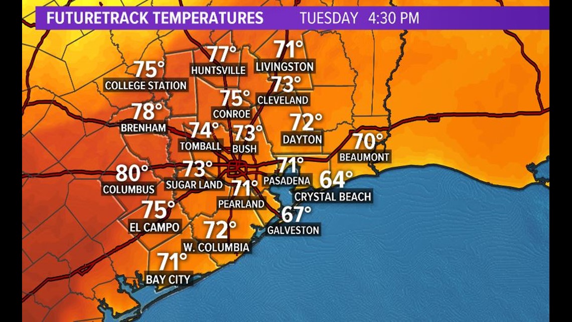
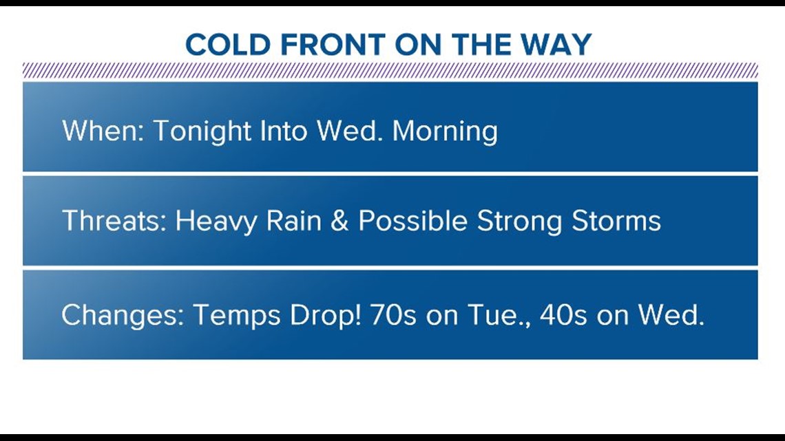
Today feels like a Spring day; with the warmth and the muggier feeling in the air (than in days past) but we'll also deal with the threat of scattered showers. As a cold front approaches from the northwest, we are pumping in the heat, as winds stay rather breezy, coming out of the south. The record high is 81, set back in 1957, and while we'll trend above average today, we'll be close to that number. So enjoy the warmth today, because tomorrow, temperatures will be a good 20-30 degrees cooler in the midday and afternoon hours.

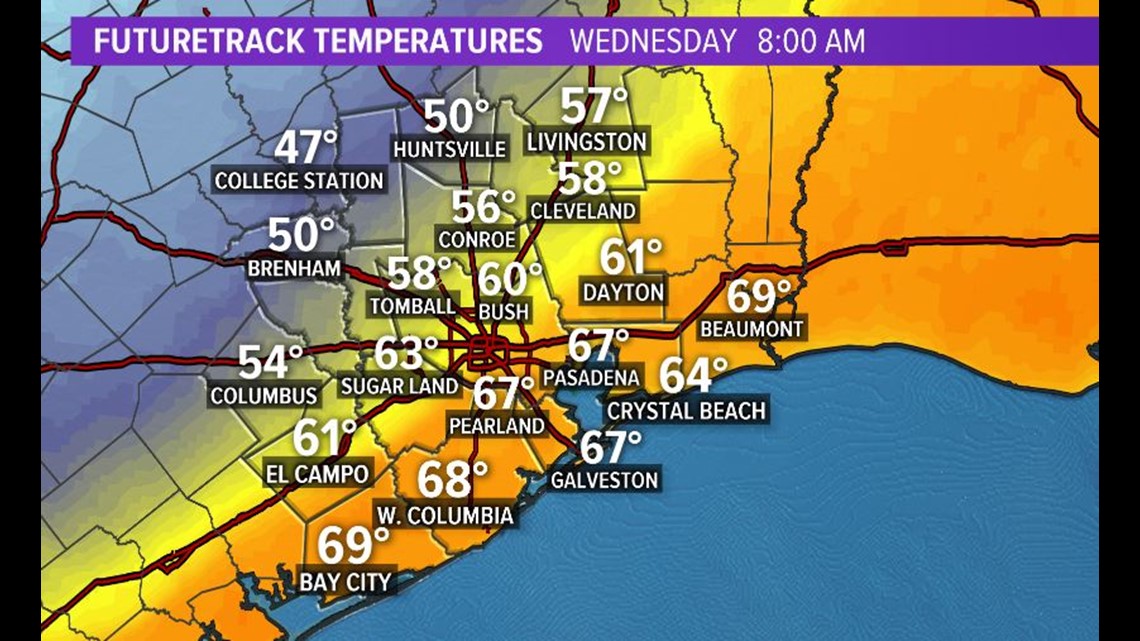
As the cold front drops through town on Wednesday morning, we'll cool down, and drastically, as the arctic air surges in. The daytime high temps will come in around midnight, and it'll all be downhill after that. Over the course of the morning rush, we'll see temps in the 60s and 70s drop to the 50s and 40s.
So that rain that will come with the cold front, will be on the chilly side, especially during the morning rush. We'll dry out later on in the day on Wednesday, but some some computer models suggest our northwest counties may see a few snow flakes before sunrise Thursday morning. But with surface temps remaining above freezing, no wintry impacts are expected here. And any flurries would happen while you are asleep.


Take a look at the EURO model and notice the pink and blue on the map. Some of our northwestern counties could see sleet and snow flakes mixed in with the rain. But also, look at the timestamp. The precipitation will wrap up before the morning rush gets underway.
Check out more details in the weather timeline below.
HOUSTON WEATHER TIMELINE:

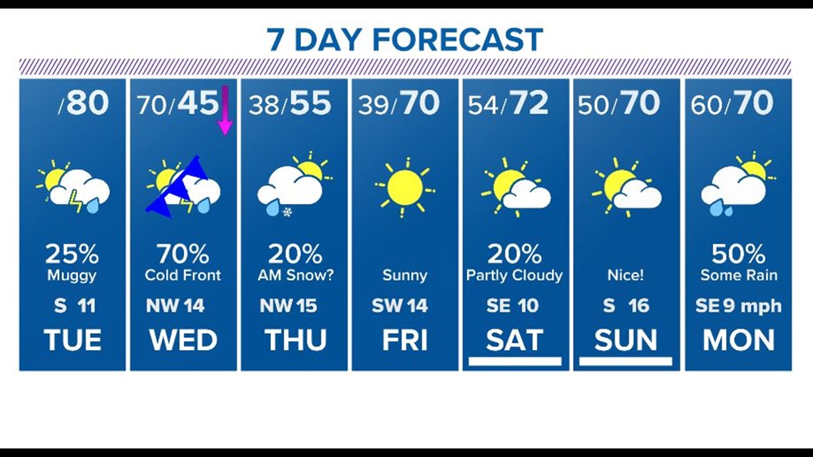
TUESDAY AFTERNOON: 30% rain chance continues throughout much of the day with temps topping out, at or close to, 80 degrees. (Late Tuesday night into very Wednesday morning is the best chance for snow/sleet in the Dallas area. Something to keep in mind if you are heading north.)
WEDNESDAY: 75% chance for scattered rain and thunderstorms, mainly in the early morning. Day starts out in the 60s & 70s but will drop into the 40s as the cold front pushes through Southeast Texas and Houston.
THURSDAY: Slight precipitation chance in the very early-morning hours (before sunrise) - this is our best chance for a mix of sleet and snow flurries. As of the latest forecast some of this could get close to Houston's north side, but the best chance for snow will be up toward Brenham, College Station, Huntsville and areas north. Don't get your hopes up too much as it won't stick to the ground, which means you may sleep through it without even knowing it snowed.
The precipitation will clear, and it will be mostly sunny in the daytime. Cold with temps in the mid-30s in the morning, only topping out in the 50s.
FRIDAY: Sunny and cool - 39 in the morning, 70 degrees in the afternoon.
THIS WEEKEND: This weekend is looking picture perfect with temps in the 60s and 70s, only a few clouds. No chance for rain.
