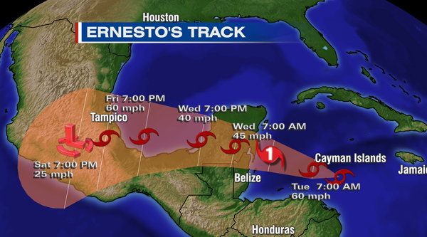
TEGUCIGALPA, Honduras -- Tropical Storm Ernesto swirled along Honduras northern coast early Tuesday, staying offshore and bringing the threat of torrential rains as it headed toward landfall as a possible hurricane near Mexico s border with Belize.
Nicaraguan authorities moved some people from low-lying areas, while Honduran officials urged people along its Caribbean coast to stay alert.
With Ernesto predicted to stay at sea while passing along Honduras northern coast during the day, Honduran authorities were monitoring the storm but there were no immediate plans to evacuate people, Roberto Diaz, operations chief of the country s Contingencies Commission, said Monday night.
We don t think is necessary to evacuate people at this point, Diaz said. We don t want to create collective panic ... and we think that ordering an evacuation would create hysteria that would affect the population more than the storm itself.
Authorities sent enough food packages to the sparsely populated area to feed 600 families for two weeks, Diaz said.
Contingencies Commission director Lisandro Rosales said the panel was urging men in the region expected to be most affected to stay alert throughout the night in case of flooding.
The river flows are still low, so we don t expect any problems, Rosales said.
Rain began falling Monday night and the region between Cabo Gracias a Dios and the city of Trujillo already had received about one inch of rain, Diaz said.
Officials in Nicaragua evacuated hundreds of people living along the coast and near the border with Honduras, Guillermo Gonzalez, who is in charge of the country s emergency services, told local television.
The scope of action will include a big chunk of the northern Caribbean coast, specifically the area between Cabo Gracias a Dios, the Misquito Cays, Puerto Cabezas and Waspam, Gonzalez said.
Ernesto could drop up to five inches of rain along Honduras coast and the northeastern shores of Nicaragua, the U.S. National Hurricane Center in Miami said.
After passing Honduras, the storm was expected to grow to near-hurricane force before moving ashore near the Belize-Mexico border early Wednesday and eventually passing into the southern Gulf of Mexico.
A tropical storm warning was issued for the coast of Honduras, from the border with Nicaragua westward to Punta Sal, including the Bay Islands. A tropical storm warning was also in effect for the east coast of the Yucatan Peninsula from north of Punta Allen to Cancun.
Hurricane warnings were posted for Mexico s Yucatan Peninsula and all of Belize s coast.
In Mexico s southern state of Tabasco, authorities warned people of possible floods in the mountains near the state of Chiapas.
There is a significant risk from water currents of several winding rivers that go into populated areas and cross highways, said Hector Perez, spokesman of Tabasco s office of the federal National Water Commission.
In the past, swollen rivers have swept away houses, livestock and people and set off landslides in the area. In a landslide last year, 31 people were buried in the Chiapas town of Juan del Grijalva.
Tabasco authorities also were taking preventive measures along the state s Gulf of Mexico coast, Civil Protection director Roberto Lopez said. He said authorities were recommending residents stay indoors and listen for emergency announcements issued by authorities.
Tabasco is a low-lying state that often floods. In 2007, heavy rains caused widespread flooding that left 1 million homes underwater and killed 33 people.
Early Tuesday, Ernesto was centered about 195 miles (315 kilometers) east-northeast of the Honduran island of Roatan, the U.S. hurricane center said. The storm had maximum sustained winds near 65 mph (100 kph) and was moving west-northwest at 13 mph (20 kph).
Far out in the Atlantic, Florence weakened to a tropical depression Monday and then dissipated, the center said.
Download our free HOU Weather app on your iPhone or Android featuring 12-hour forecasts, radars,conditions, coastal weather, Texas weather, webcams, satellite imagery and travel.