

HOUSTON — Harold was downgraded to a tropical depression Tuesday afternoon after slamming into the South Texas coastline as a tropical storm.
It made landfall on Padre Island in South Texas just before 10 a.m., according to the National Hurricane Center.
The system, which strengthened into a tropical storm early Tuesday, was expected to bring about 3 to 5 inches of rain to South Texas. Some areas could even see as much as 7 inches of rain, NHC reported. A couple of tornadoes were also possible across South Texas.
It is expected that this tropical storm will stay south of Southeast Texas.
A few showers and storms are possible across the area but totals should remain very low.
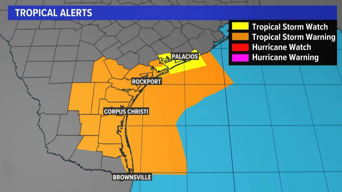
There is a Tropical Storm Warning already in effect for South Texas, according to the NHC. Closer to home, there is a Tropical Storm Watch for Matagorda Bay. Strong winds could cause dangerous conditions for boaters.
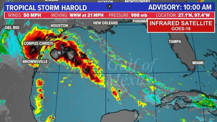
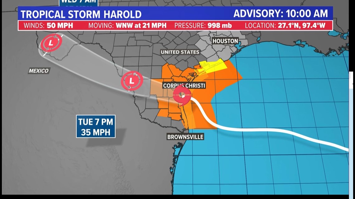
Tropical Storm Harold 10 a.m. advisory
Tropical Storm Harold is about 35 miles north of Port Mansfield, Texas, and 50 miles south of Corpus Christi with a maximum sustained winds of 50 mph.
The storm is moving west-northwest at 21 mph. This general motion is expected to continue through tonight, and the
system is forecast to move inland over South Texas by midday today.

Tropical Storm Harold watches and warnings
A Tropical Storm Warning has been issued for portions of South Texas south of Port O'Connor. A Tropical Storm Watch has been issued from Port O'Connor northward to Sargent.
- A Tropical Storm Warning is in effect for the mouth of Rio Grande to Port O'Connor, Texas
- A Tropical Storm Watch is in effect for Port O'Connor to Sargent, Texas.
Interests elsewhere in eastern Texas and northern Mexico should monitor the progress of this system.
What does a Tropical Storm Warning mean?
A Tropical Storm Warning means that tropical storm conditions are expected somewhere within the warning area, in this case within 24 hours.
What does a Tropical Storm Watch mean?
A Tropical Storm Watch means that tropical storm conditions are possible within the watch area, in this case within 24 hours.

Tropical Storm Harold key messages
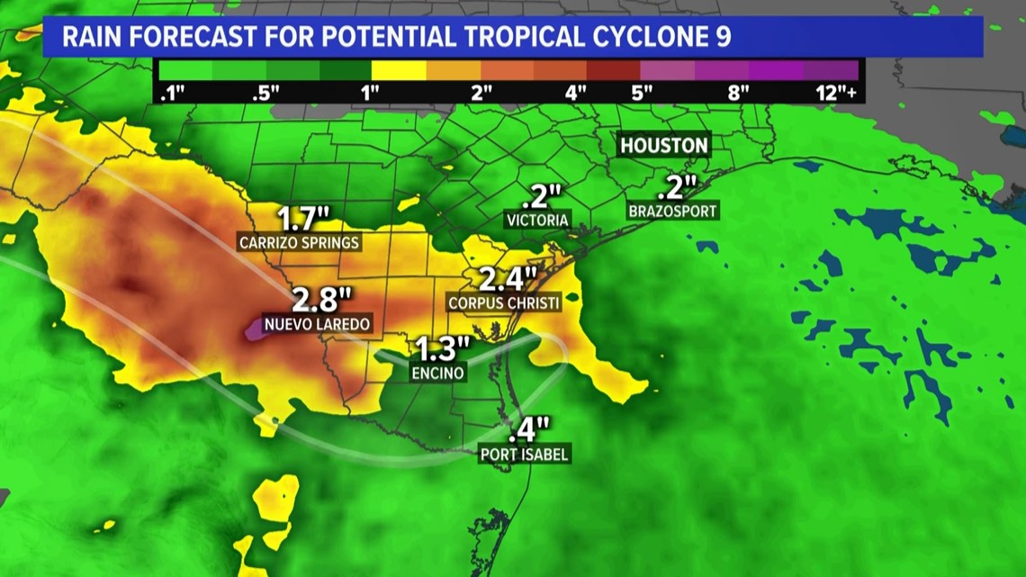
Heavy rainfall from Tropical Storm Harold is expected across South Texas on Tuesday and Wednesday. The heavy rainfall may produce areas of flash and urban flooding. Across portions of Coahilla and Nuevo Leon in Mexico, flash flooding with possible landslides in mountainous terrain is expected Tuesday into Wednesday.
Coastal flooding is possible along the South Texas coast Monday night through Tuesday morning.
Tropical storm conditions are expected in the warning area and are possible in the watch area beginning Tuesday morning.
Rainfall
Potential Tropical Cyclone Nine is expected to produce storm total rainfall amounts of 2 to 4 inches, with isolated higher amounts of 6 inches, across Southern Texas on Tuesday and early Wednesday.
This rainfall could lead to areas of flash and urban flooding.
Across Mexico, storm total rainfall of 4 to 6 inches, with local amounts of 10 inches, is expected across portions of Coahilla and Nuevo Leon on Tuesday and Wednesday. Areas of flash and urban flooding are expected.

Wind
Tropical storm conditions are expected in the warning area and are possible in the watch area beginning early today.
Storm Surge
The combination of a storm surge and the tide will cause normally dry areas near the coast to be flooded by rising waters moving inland from the shoreline. The water could reach the following heights above ground somewhere in the indicated areas if the peak surge occurs at the time of high tide, the mouth of Rio Grande to Sargent, including Baffin Bay, Corpus Christi Bay and Matagorda Bay, 1 to 3 feet.
The deepest water will occur along the immediate coast near and to the north of the landfall location, where the surge will be accompanied by large waves. Surge-related flooding depends on the relative timing of the surge and the tidal cycle and can vary greatly over short distances.
Tornadoes
A couple of tornadoes are possible across South Texas through the afternoon.
Surf
Large swells will affect portions of southern Texas through Tuesday. These swells are likely to cause life-threatening surf and rip current conditions.
Tropical update
Beyond this tropical depression, there are three named systems - one tropical depression and two tropical storms - along with a tropical wave in the Eastern Atlantic that the National Hurricane Center is watching. Right now, none of these others pose a threat to the United States.
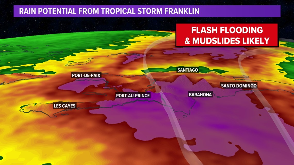
Tropical Storm Franklin will impact Hispaniola by the middle of the week as a strong tropical storm with winds near 50 mph.

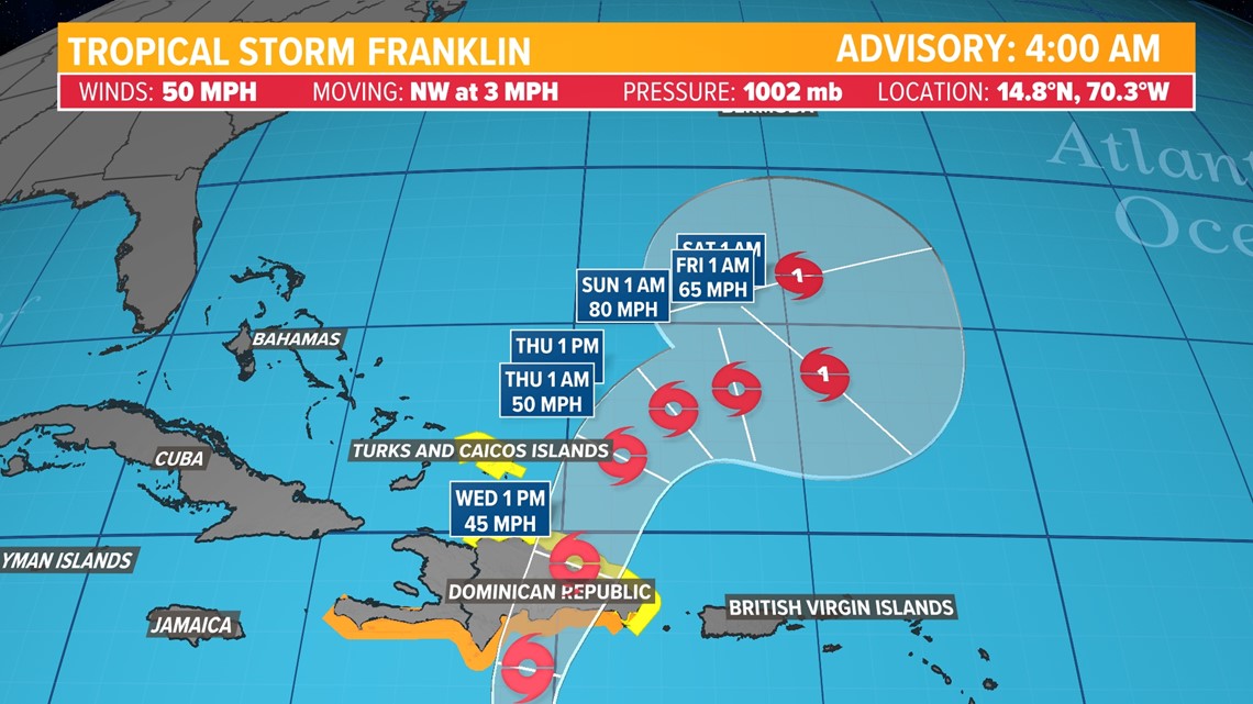
Franklin will drop tons of rain on the island, which may lead to flash flooding and mudslides, especially on the south side of the island as it makes landfall.

The KHOU 11 Weather Team encourages everyone to keep an eye out on the forecast at least once a day through the weekend and next week so you're not caught off guard just in case something stronger is able to develop.
2023 Atlantic hurricane season predictions
The National Oceanic and Atmospheric Administration recently doubled the chances of a nasty Atlantic hurricane season this summer and fall.
The agency said there's a 60% chance for an above-normal hurricane season, twice the agency's May forecast which said it was 30%. The earlier forecast leaned more toward a near-normal season with a 40%, but the chance for normal has now shrunk to 25%.
Although the NOAA outlook doesn’t forecast storm tracks or what places will get hit, a busy season like the one forecast means “there is a doubling of the chance of a hurricane making landfall on the East Coast of the U.S.,” said Matthew Rosencrans, lead hurricane season forecaster with NOAA’s Climate Prediction Center.
NOAA is now forecasting between 14 to 21 named storms, which is an increase over forecasters' initial May forecast of 12 to 17. A normal year has 14 named storms.
Of those named storms, NOAA predicts six to 11 will become hurricanes, which is more than the five to nine predicted in May. Normal is seven hurricanes. Of those hurricanes, NOAA predicts two to five will become major hurricanes with winds of more than 110 mph, which is one more than earlier predictions. A normal year sees three major hurricanes.
Follow the KHOU 11 Weather Team to stay up-to-date on the local forecast and what's brewing in the tropics:
