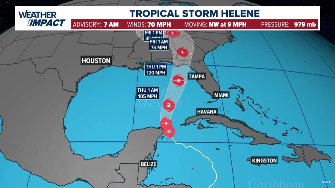
HOUSTON — Tropical Storm Helene formed in the northwestern Caribbean Sea Tuesday morning, according to the National Hurricane Center.
The forecast track from the NHC continues to take aim at Florida, in particular the Florida Big Bend area. Helene is forecast to become a major Category 3 storm before making landfall late Thursday afternoon or early Thursday evening.
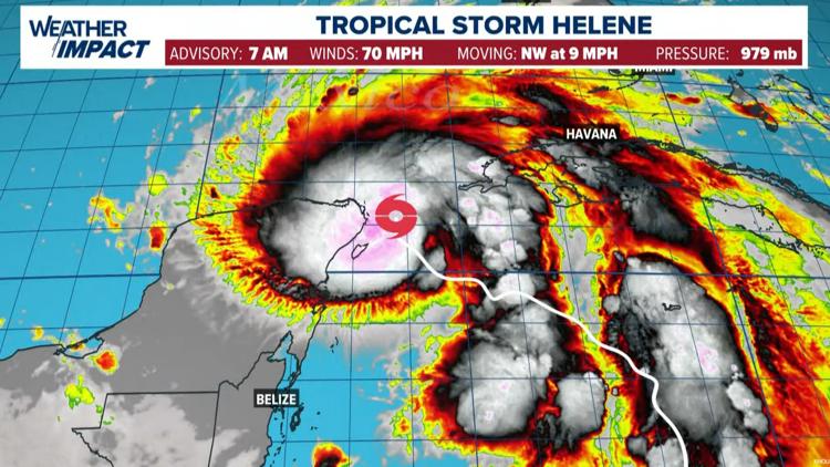
As of 7 a.m., Helene has maximum sustained winds of 70 mph and is moving northwest at 9 mph. It is 100 miles southwest of the western tip of Cuba.
There is the possibility that the storm could become stronger than Category 3. If the system can move out of the Caribbean and into the Gulf of Mexico without interacting with the land mass of Cuba or the Yucatan, this could allow for the circulation to rapidly intensify without being disturbed as it traverses the eastern Gulf. Sea surface temperatures are plenty warm and wind shear is expected to be light over the Gulf. That's what you need to possibly see rapid intensification beyond what is currently forecast.
RELATED: 2024 Hurricane Preparedness Guide
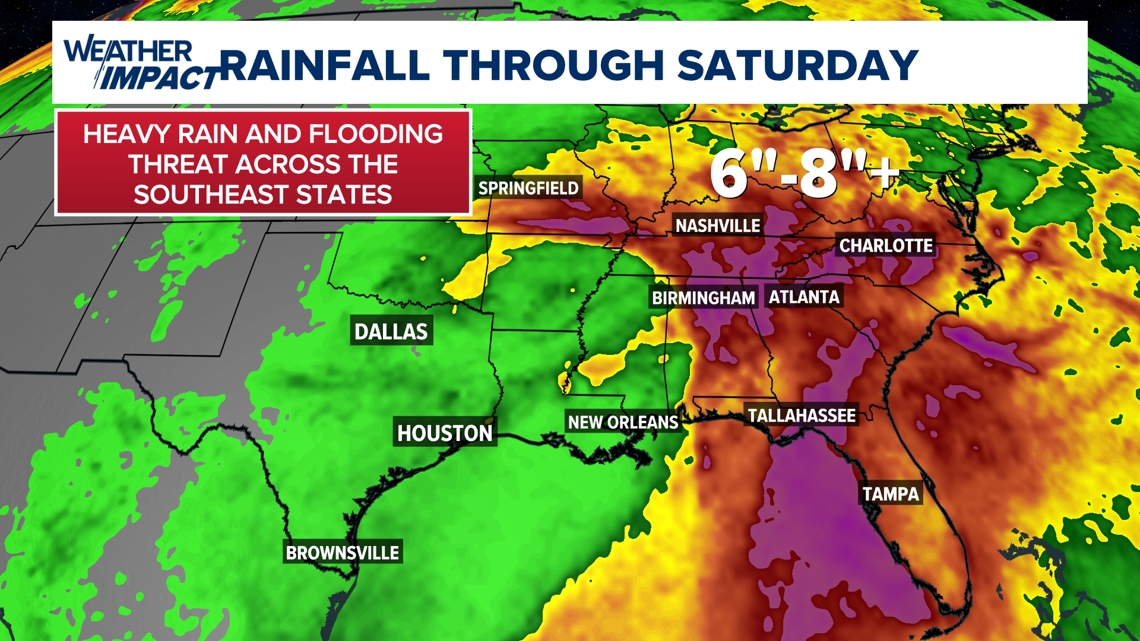
After landfall, the storm will bring heavy rain and flash flooding threat to a large portion of the southern and eastern United States. Six to eight inches of rain and possibly much more will likely lead to dangerous flooding of roads and possibly homes from Georgia to the Carolinas and west all the way to Missouri.
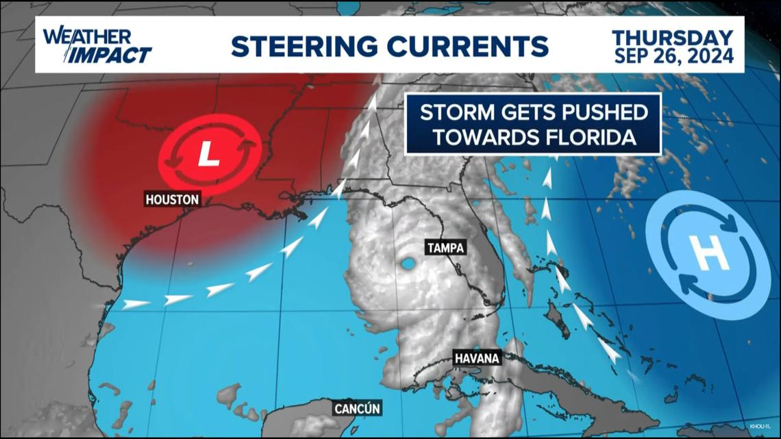
What will keep the storm away from Texas?
The storm will be steered away from Texas by the upper-level steering currents. That's the flow around an area of low pressure to our west and the flow around the high-pressure area to our east. This pattern is creating a river of air moving north toward Florida and away from Texas. The storm will move with this flow following the path of least resistance in the southeast United States.

s
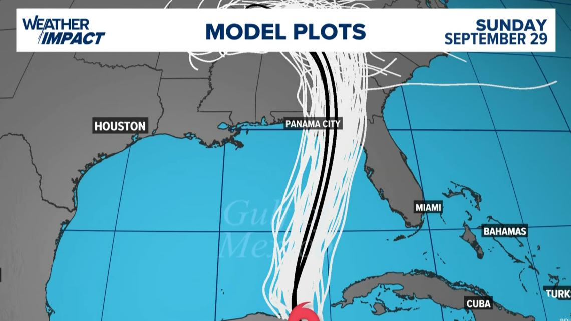
Tropical Storm Helene track

Tropical Storm Helene Models

Rainfall from what's expected to become Hurricane Helene

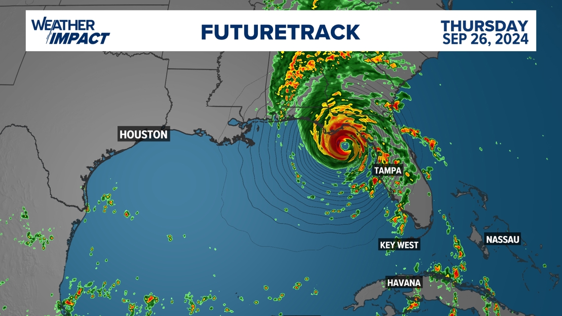
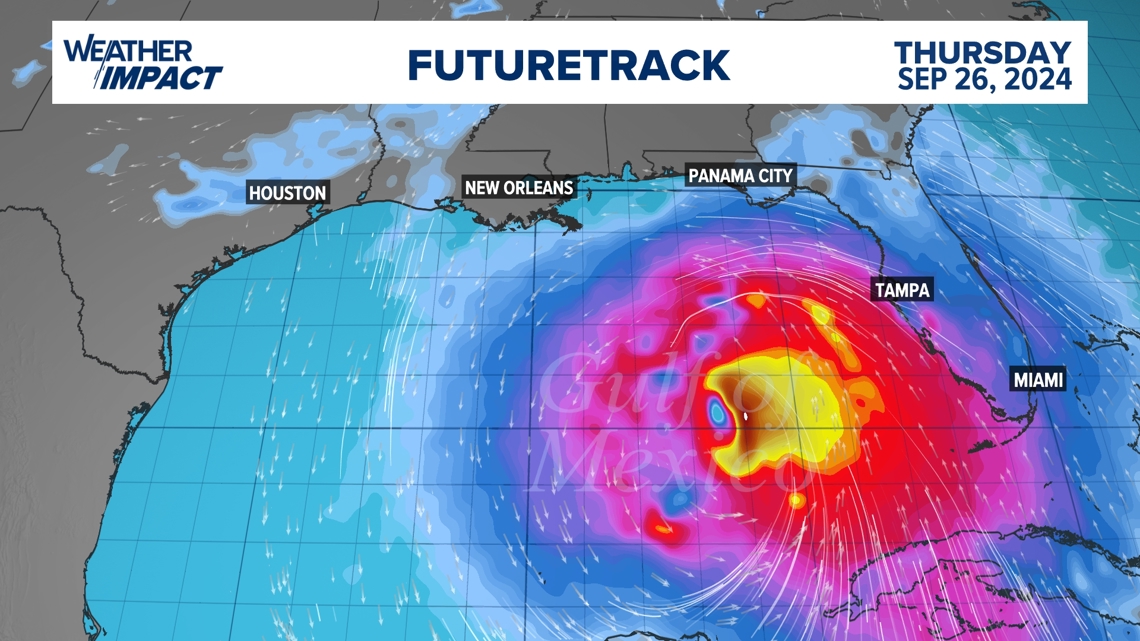
Futuretrack of what's expected to become Hurricane Helene

For Southeast Texas, weather models also agree that we will see a cold front sweep through by the end of the week that could bring us a break from the humidity with slightly cooler temperatures. It will be this system that will keep whatever forms in the Gulf well east of us.
Obviously though, because of its proximity to the Gulf of Mexico, it is a storm that we will need to watch daily so no one gets caught off guard if the storm ends up heading our way.
An important reminder is that there is still a degree of uncertainty since we do not have a closed-off low-pressure system at the moment. This will likely happen by the middle of the week. When this occurs, we will have a better idea of the true impacts of this system.

Tropical Storm Helene Warnings
Verbatim from the National Hurricane Center
A Tropical Storm Warning has been issued for the Middle Florida Keys from the Seven Mile Bridge to the Channel 5 Bridge. A Tropical
Storm Warning has been issued for the Gulf coast of Florida from Flamingo northward to Anclote River, including Tampa Bay, and west
of Mexico Beach to the Walton/Bay County Line.
A Tropical Storm Watch has been issued for the east coasts of Florida and Georgia from the Palm Beach/Martin County Line northward to the Savannah River, and for Lake Okeechobee.
A Storm Surge Watch is in effect for:
- Indian Pass southward to Flamingo
- Tampa Bay
- Charlotte Harbor
A Hurricane Warning is in effect for:
- Anclote River to Mexico Beach, Florida
- Cabo Catoche to Tulum, Mexico including Cozumel
A Hurricane Watch is in effect for:
- Cuban province of Pinar del Rio
- Englewood to Anclote River, including Tampa Bay
A Tropical Storm Warning is in effect for:
- Dry Tortugas
- All of the Florida Keys
- The Florida west coast from Flamingo to Anclote River, including Tampa Bay
- West of Mexico Beach to the Walton/Bay County Line
- The Florida east coast from Flamingo northward to the mouth of the St. Mary's River
- Lake Okeechobee
- Rio Lagartos to Cabo Catoche, Mexico
- Cuban provinces of Artemisa, Pinar del Rio, and the Isle of Youth
A Tropical Storm Watch is in effect for:
- The Georgia and South Carolina coast north of the mouth of the St. Mary's River to the South Santee River
What is a Storm Surge Warning?
A Storm Surge Warning means there is a danger of life-threatening inundation, from rising water moving inland from the coastline, during the next 36 hours in the indicated locations. This is a life-threatening situation. Persons located within these areas should take all necessary actions to protect life and property from rising water and the potential for other dangerous conditions. Promptly follow evacuation and other instructions from local officials.
What is a Tropical Storm Warning?
A Tropical Storm Warning means that tropical storm conditions are expected somewhere within the warning area, in this case within the next 24 to 36 hours.
What is a Tropical Storm Watch?
A Tropical Storm Watch means that tropical storm conditions are possible within the watch area, generally within 48 hours.
What is a Hurricane Warning?
A Hurricane Warning means that hurricane conditions are expected somewhere within the warning area. A warning is typically issued 36 hours before the anticipated first occurrence of tropical storm-force winds, conditions that make outside preparations difficult or dangerous. Preparations to protect life and property should be rushed to completion.
What is a Hurricane Watch?
A Hurricane Watch means that hurricane conditions are possible within the watch area. A watch is typically issued 48 hours before the anticipated first occurrence of tropical-storm-force winds, conditions that make outside preparations difficult or dangerous.
Check back multiple times a day as we continue to watch for potential development. You can also download the KHOU 11 app for updates sent to your phone.
What is a Storm Surge Watch
A Storm Surge Watch means there is a possibility of life-threatening inundation, from rising water moving inland from the coastline, in the indicated locations during the next 48 hours.