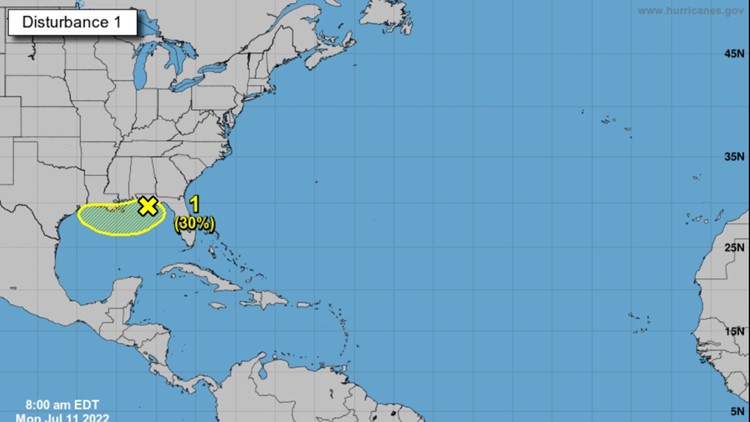
HOUSTON — A surface trough of low pressure is over the northern Gulf of Mexico just offshore of the Florida Panhandle, according to the National Hurricane Center.
The NHC says the surface pressures in the Gulf have begun to fall over the past 24 hours.
Gradual development of this system is possible if it remains offshore during the middle and latter part of the week as it drifts slowly over the northern Gulf of Mexico, according to NHC.
Regardless of development, heavy rains will be possible along portions of the northern Gulf coast from Louisiana to the Florida Panhandle over the next several days, according to NHC.
Gulf Forecast
From the National Hurricane Center:
"A weak ridge continues to dominate the Gulf waters supporting mainly light and gentle winds, except moderate to locally fresh southerly winds over the far northwest Gulf. A surface trough is analyzed from inland the Florida Panhandle, south-southwest to Apalachicola and out over the Gulf to near 29N87W.
Scattered showers and isolated thunderstorms are seen within 120 nautical miles either side of the trough north of 28N. Isolated showers and thunderstorms are from 25N to 28N between 85W-89W. Areas of rain, with embedded scattered showers and isolated thunderstorms are from 21N to 25N between 87W-90W.
Moderate to fresh northeast to east winds are just west of the Yucatan peninsula due to the an enhanced gradient related to the Yucatan Peninsula trough that has shifted to offshore.
Buoy observations along with recent altimeter data indicate seas of 3 feet or less throughout, except for higher seas of 3 to 5 feet in the central Bay of Campeche.
For the forecast, surface ridging extending across the basin will maintain light to gentle return flow east of 90W through the forecast period, except over the far northeast part of the basin where a slighter tighter gradient near the aforementioned surface trough will support moderate to fresh southwest winds.
Gentle to moderate southerly winds west of 94W will increase to moderate to fresh speeds at night through Thursday, while diminishing back to gentle to moderate speeds by early in the afternoons as broad low pressure develops over Texas and northeastern Mexico.
Light to gentle winds are expected across the Gulf on Friday, except over the eastern Bay of Campeche where winds will be enhanced by a thermal trough coming off the Yucatan peninsula at night.
Southerly winds may be enhanced over sections of the north-central and northeast Gulf from Wednesday through Friday night associated to the surface trough or to low pressure that may form from the trough."
Hurricane season: Interactive storm tracker; supply lists, evacuation info and more
The 2022 Atlantic Hurricane Season is here and we want to make sure you're prepared. It's expected to be an active season, so make sure you have everything you need to keep yourself, your home and your family safe if a storm comes our way. And make sure you have the KHOU 11 news app to stay updated when you're not in front of your TV or computer.


