AUSTIN, Texas — Editor's note: This live weather blog is no longer being updated. Click here for Friday's live weather blog.
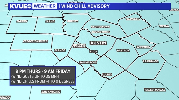
*A Winter Storm Warning is in effect for most counties in the KVUE viewing area for until 10 a.m. on Friday, Feb. 4. A Wind Chill Advisory is also in effect through 9 a.m. Friday.*
All of the sleet and freezing rain has come to an end for Central Texas, but now we turn our attention to the cold and the wind chills. A Wind Chill Advisory has been issued for all of Central Texas for wind chills in the single digits to even below zero in some locations.
Air temperatures will drop down the teens and low 20s by Friday morning. So although the precipitation has ended, we're still looking out for slick spots on bridges and overpasses as well as possibly some black ice overnight into Friday morning. The National Weather Service has extended the Winter Storm Warning through 10 a.m. on Friday to account for potential hazardous driving. Please be very cautious if you have plans to drive and take it slow on the elevated roads.
Much of Central Texas will likely warm above freezing for Friday afternoon with sunshine that should end most of our lingering icy concerns. However, we can't rule out a few slick spots into Saturday morning as the coldest locations may stay below freezing until then.
The weekend forecast looks much improved. The mornings still look very cold, but the afternoon will bring sunshine and afternoon highs that are safely above freezing. Stay warm, y'all.
Live weather updates
8:40 p.m. - The National Weather Service extended the Winter Storm Warning until 10 a.m. Friday. The NWS cited ongoing hazardous travel conditions and icy roads for the extension.
6:09 p.m. - The National Weather Service reports wind chills tonight ranging from below zero to the teens.
4:37 p.m. - The Austin Fire Department (AFD) said from 9 a.m. to 4 p.m. on Feb. 3, the department has responded to the following calls for service:
- Total incidents: 128
- Fires: 6
- Traffic accidents/injuries: 10
- Wires down/arcing: 4
- Broken water pipes: 2
4 p.m. - Reports from the National Weather Service show the highest sleet totals reported so far were in Llano and Williamson counties with a total of 0.8 inches. The highest reported freezing rain accumulation so far is in Travis County is at 0.3 inches. Additional reports are expected later.
3:20 p.m. - A Wind Chill Advisory has been issued for Central Texas from 9 p.m. Thursday though 9 a.m. Friday. Wind chills are expected to be in the single digits late Thursday through Friday morning.
2:10 p.m. - A large hill at Spicewood Springs near the Capitol is solid ice with a couple of stranded vehicles. Avoid that road.
12:40 p.m. - Another band of precipitation is developing west of Austin.
12:30 p.m. - Williamson County Judge Bill Gravell tells Tony Plohetski that his crews say 95% of roads in the county are impacted by the winter weather and that certain roads are impassable due to ice. He says if you get on the road, you will encounter ice. He is asking people to stay home.
11:59 a.m. - Crews with the Texas Department of Transportation in South Austin are heading out to lay down more de-icer. With temps so low, what melts is likely to refreeze. Avoid travel if you can.
11:57 a.m. - Mason County has been dropped from the Winter Storm Warning. Most other counties in Central Texas are under the warning until 9 p.m.
11:03 a.m. - Near Hyde Park, the road is closed due to a fallen tree and burst water main on Duval Street northbound from 45th to 46th streets.
10:19 a.m. - The Austin Fire Department said that from 9 a.m. on Feb. 2 through 9 a.m. on Feb. 3, the department has responded to the following calls for service:
- Total incidents: 298
- Fires: 17
- Traffic accidents/injuries: 45
- Wires arcing: 5
10:06 a.m. - We're tracking a little bit of everything this morning. Shane Hinton is starting to see conditions drying up (regarding falling precip) west in the Hill Country.
9:40 a.m. - The wintry mix continues pushing east. The clearing is expected from west to east. Snow flurries are possible but ice/sleet is the main concern. Precipitation should move out of the area by 6 p.m. Very cold and windy conditions remain for the evening and overnight hours.
9:30 a.m. - We received a report of snow flurries in Mason County, however, the National Weather Service has not confirmed snow in that area yet. Snow flurries are possible Thursday, but the main concern is sleet and ice.
8:45 a.m. - We're currently tracking gusts around 30 mph across Central Texas. This means the "feels like" temperatures are in the teens in the Hill Country and in the 20s for Austin and areas east.
8:42 a.m. - Lots of sleet and freezing rain across Central Texas this morning. Stay off the roads and stay home if you can!
8:34 a.m. - According to Austin Energy, there are now less than 400 people without electricity in Austin now. The concern for more outages exists as temperatures drop.
8:28 a.m. - The first report of freezing rain in Fayette County near La Grange has come in.
7:54 a.m. - Temperatures will decline throughout the day and so will our precipitation chances. Any wintry precipitation should move out of the area around the early evening hours. At that point, our focus will turn to bone-chilling wind chills.
7:30 a.m. - As the sun starts to rise, residents are waking up to blankets of ice outside their doors. That is ice, not snow! That's according to the National Weather Service.
6:30 a.m. – KVUE Senior Reporter Tony Plohetski spoke to Williamson County Judge Bill Gravell, who said State Highway 29 is becoming a dividing line between what is frozen and what isn't in Williamson County. Gravell said to the north, significant ice has been accumulating, but to the south, ice had only just begun to accumulate at around 6:15 a.m.
Gravell also told KVUE that since midnight, Williamson County had seen seven accidents due to wet roads, with two people taken to the hospital. Four roads were closed in Williamson County as of 6:30 a.m. due to flooding.
Plohetski also spoke with the Cedar Park and Georgetown police departments. Cedar Park police reported no accidents or road closures, while Georgetown reported one crash since midnight. Georgetown police said ice is increasingly accumulating on roads in the city.
6:29 a.m. - The National Weather Service says significant icing will be ongoing across the Hill Country and developing into the I-35 corridor through the morning hours and eastern areas through the afternoon. One-tenth to a quarter of an inch of ice accumulation is expected across the area. There may be isolated higher amounts.
6:10 a.m. - Gusts up to 30 mph across the area are bringing a strong wind chill. Temperatures feel like they're in the teens in the Hill Country and toward the northern portion of I-35.
6:15 a.m. - Williamson County officials say State Highway 29 has become a dividing line between what is frozen or not, according to KVUE's Tony Plohetski. To the north, officials report accumulating ice. To the south, ice is just starting to form. Crews have responded to seven crashes, two involving injuries.
5:41 a.m. - Temperatures continue to drop west to east. Areas east of I-35 are now at freezing as radar shows a transition into a wintry mix.
5:34 a.m. - The water rescue patient on Gregg Lane has been rescued. A rescuer there is being evaluated for hypothermia.
5:20 a.m. - A Flood Advisory has been issued for portions of Travis, Hays and Williamson counties as they experience minor flooding in low-lying regions and poor drainage areas. This is in effect until 7:30 a.m.
5:06 a.m. - Conner Board in Round Rock said the past half hour she's witnessed rain and sleet, which is starting to turn to ice on the ground. You'll want to avoid the roadways as conditions are starting to worsen.
5:06 a.m. - About 60 low water crossings are closed in Central Texas due to flooding.
5 a.m. - The National Weather Service reports that the icing event has begun across South and Central Texas. The NWS said they've already received freezing rain reports from Downtown Austin.
4:59 a.m. - Austin-Travis County EMS is responding to a water rescue in the 10708 block of Gregg Lane. A vehicle at a low water crossing is stopped and a person is on top of the car.
Timeline: Significant icing begins Wednesday night
Freezing rain and sleet began overnight across the Hill Country. Impacts were first felt across Mason and Llano counties as temperatures continue to plummet on Thursday morning.
Meanwhile, regular rain and downpours will be ongoing for much of the Interstate 35 corridor with temperatures in the upper 30s and 40s. Freezing rain and sleet developed across the northern I-35 corridor and parts of the Austin metro as early as about 5 a.m.
Travel is becoming quickly dangerous at this point. This is why we want everyone at home and off the roads.

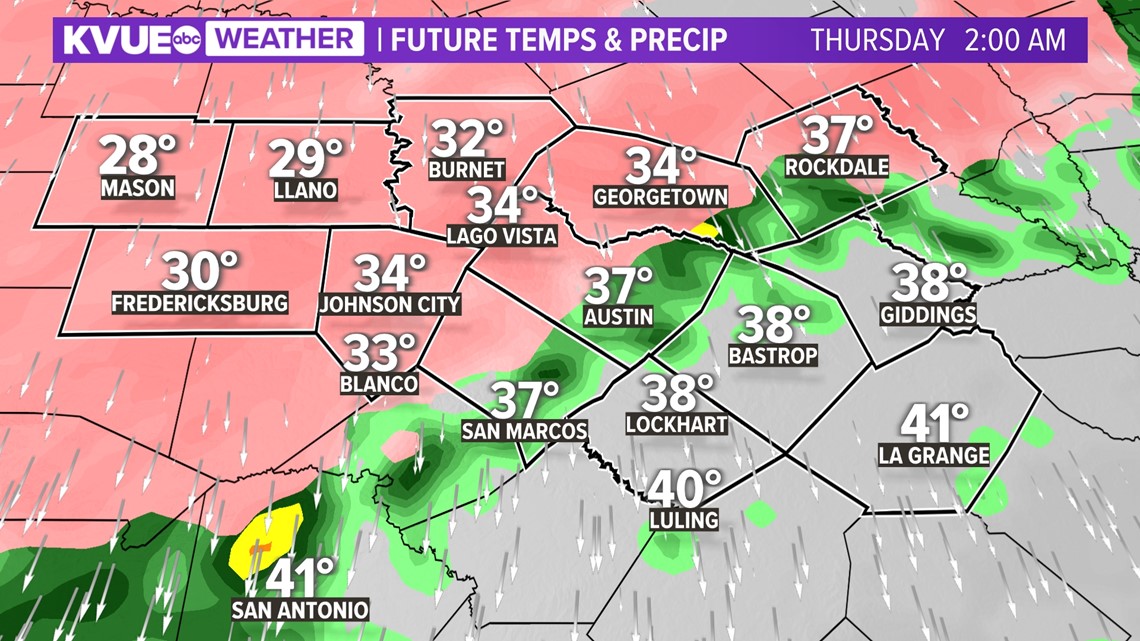
By Thursday morning, freezing rain and sleet will be widespread and significant icing will be ongoing for all of Central Texas. Forecast models have indicated the possibility of a few snow flurries throughout the region, but no significant snowfall accumulation is expected at this time.
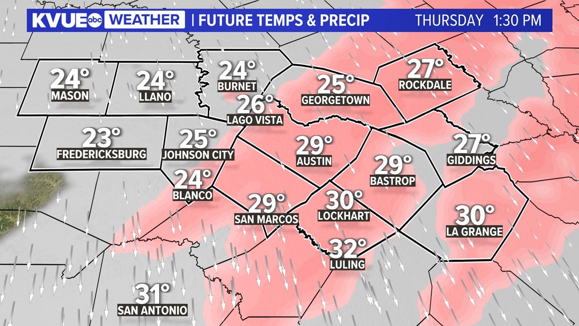
Widespread freezing rain and sleet continue through the morning and into the afternoon as temperatures continue to drop. Temperatures will stay below freezing all day on Thursday.

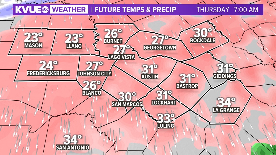
Precipitation will come to an end from west to east through Thursday afternoon and early evening. The wintry precipitation should be gone by 8 p.m. or so.
Then we look ahead to a hard freeze Friday morning as temperatures drop to the teens and low 20s.

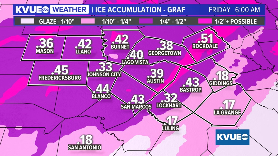
How much ice and what will it mean?
Significant ice totals up to a half-inch are likely for Central Texas. On average, most locations will receive up to a quarter to a third of an inch of ice, but some locations could receive as much as a half-inch of ice.
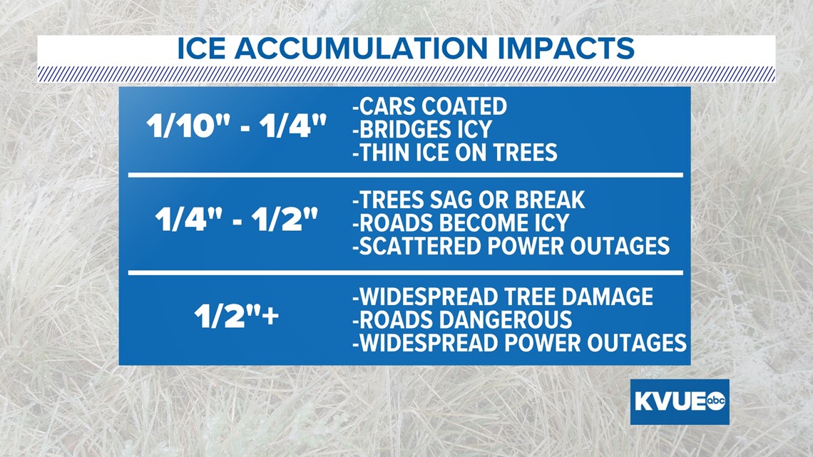
This is a lot of ice for Central Texas and is enough to create widespread travel issues or even impassable roads. It is also enough to weigh down tree limbs and power lines to create scattered power outages.

Below is a breakdown of what the different ice amounts mean for impacts. We can look at potential ice totals all day long, but the bottom line is that travel is going to be very messy to nearly impossible, and scattered power outages will be a possibility.

How cold it will it get and how long will the ice last?
Outside of the sleet and freezing rain, we are also tracking very cold temperatures and an extended stretch of subfreezing temperatures. It won't be anywhere close to February 2021, but we still want everyone to be prepared.
Air temperatures drop below freezing for most of the KVUE area by Thursday morning and will stay below freezing through at least Friday morning. It's possible that portions of Central Texas stay below freezing even through Friday afternoon and into Saturday morning.
This means icy travel could persist from Thursday morning into as late as Saturday for some areas. We advise everybody to stay indoors and off the roads through at least Thursday and Friday if at all possible.
Also remember to make plans for the four Ps: people, pipes, pets and plants. Morning temperatures in the teens will be widespread by Friday morning, perhaps even in Austin.

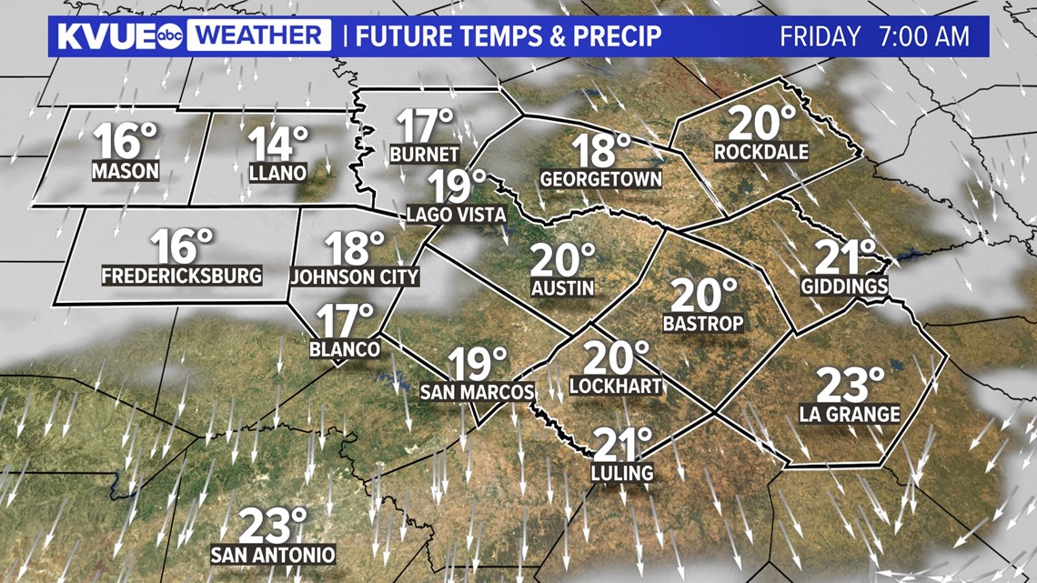
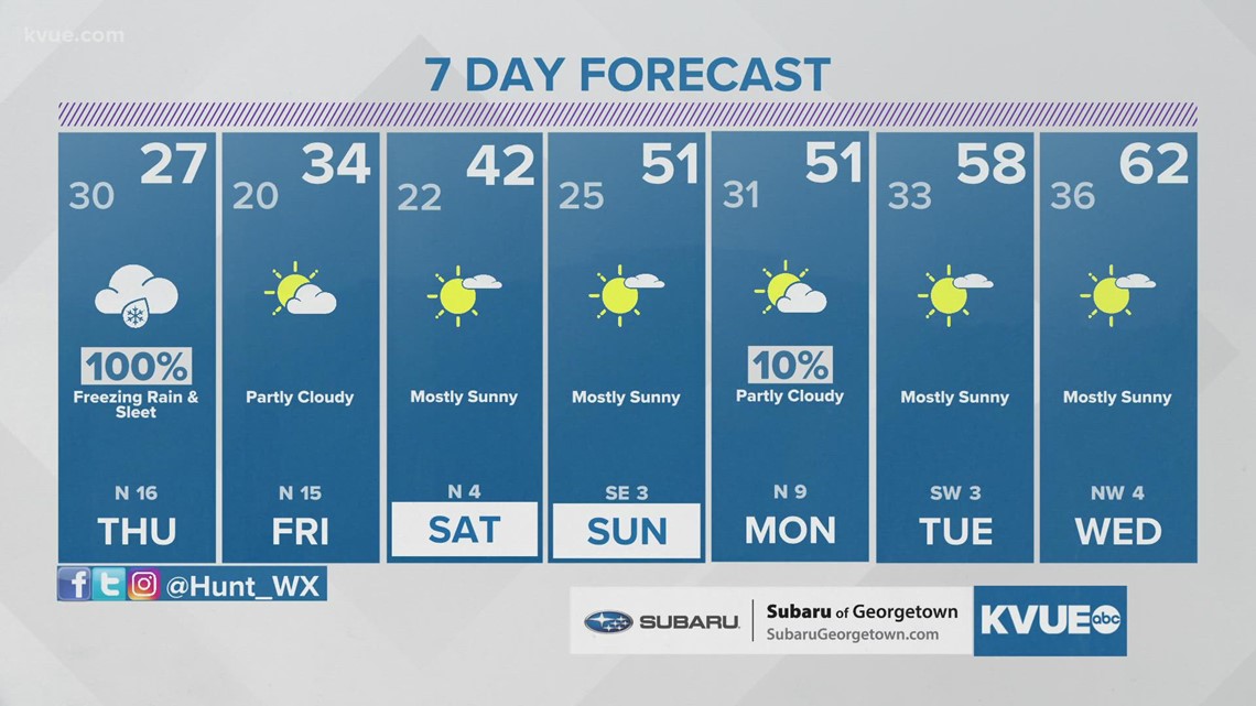
Additional hard freezes are likely for Saturday and Sunday mornings. Even into Monday morning we're expecting Austin to drop down to the low 30s.

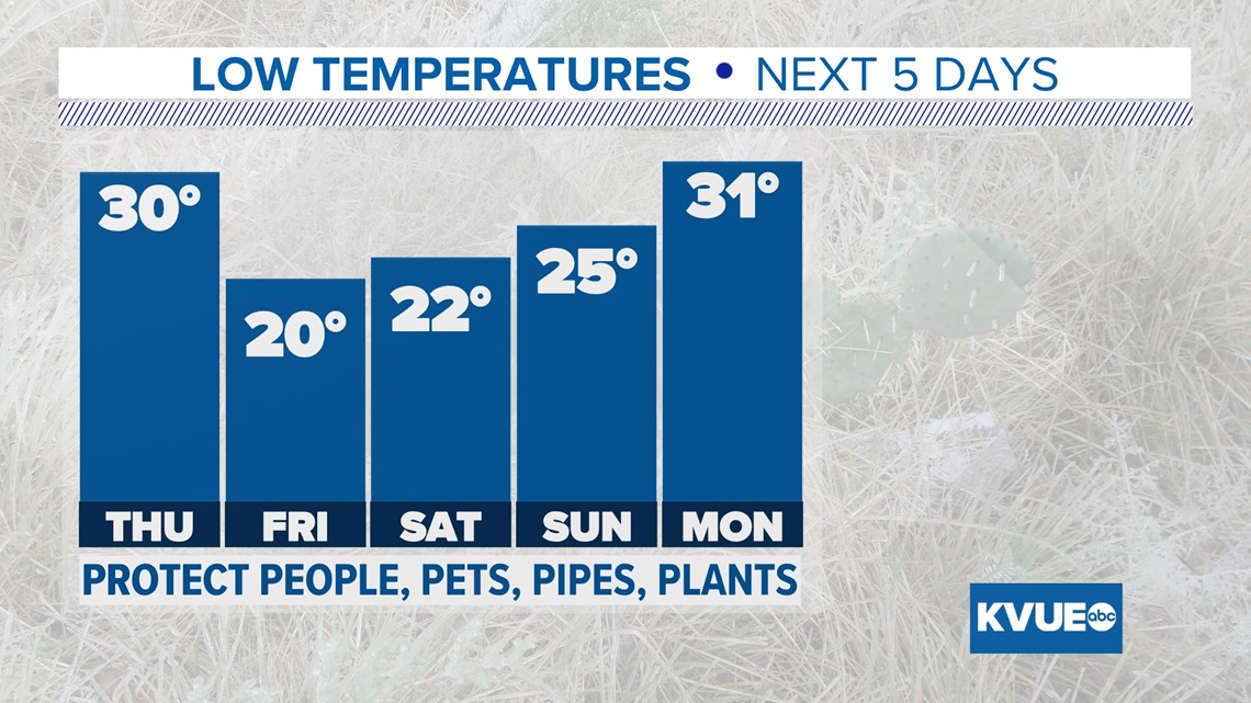
Afternoons should warm safely above freezing by Saturday and Sunday, and highs will be around 60 by Tuesday of next week.
The KVUE Storm Team will continue to monitor this developing forecast.
In the meantime, the extended forecast can be found below:

