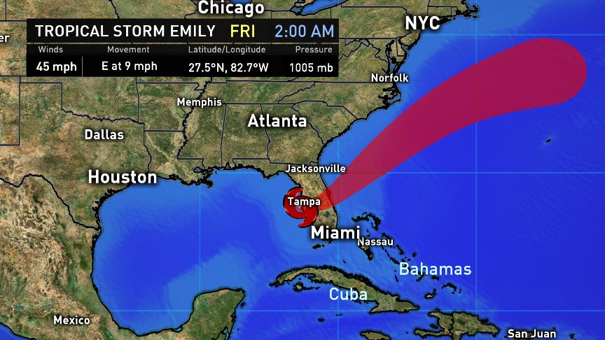
TV forecasters this morning along Florida's Gulf Coast dutifully relayed a message from the National Hurricane Center: "A disturbance off of Tampa has a 40% chance to develop in the next 48 hours." Several of those meteorologist further speculated, "I don't see this as likely to happen. It'll probably come on-shore before it has time to develop." Several hours later, before the same morning newscast was even over, a full-blown tropical storm had developed, only to make landfall before the mid-morning talk shows. Were meteorologists generally unprepared? Was it due to a predisposition to lean on the computer models (which largely missed this) to make a short-range forecast instead of, "looking out of the window" at current radar and barometric pressures trends? Was it a reminder to never speculate as to whether or not, "it may or may not form" unless you're seriously, really, wholly, darned sure? Yes, yes, and yes. Am I condemning their efforts? NO. We've all been caught by surprise.
Tropical Storm Emily in FL went from a, "40% chance to develop in the next 48hrs" per the #NHC one hour, to a full-blown TS the next! 🤔Yeah. pic.twitter.com/OoQqUgxiHX
— Brooks Garner (@BrooksKHOU) July 31, 2017
From our vantage point in Houston, it's been a beautiful morning thanks to the drier air that arrived last night, behind a rare late-July cold front. Fronts like this can produce copious amounts of thunderstorm activity in the open Gulf, as the unusually dry air surges south. That's what happened last night. Along these cold front boundaries, thunderstorm complexes sitting atop 88°F sea water temperature can quickly become tropical low pressure centers.
Tropical Storm Emily making landfall near Ana Maria Island, FL. Flooding is main threat. pic.twitter.com/czWasi9oi9
— Brooks Garner (@BrooksKHOU) July 31, 2017
To their credit, the National Hurricane Center did forecast this area as being a potential hot spot for activity -- though at just a 40% chance, they way under-estimated the potential. However, they were quite astute in nailing the the location. It's just that they didn't think it would actually happen. This was yet again, an example of how despite our advance technology, tropical weather is still truly unpredictable. It's chaos theory. It's butterfly effect. It's a forecast based on knowledge we've not yet gained and one which we're thus ill prepared to make. At risk of sounding too cynical, a popular TV show in the 1960s best describes this 'zone' of forecasting:
"Somewhere between the pit of man's fears and the summit of his knowledge ... it is an area we call, The Twilight Zone."

This should be a reminder to expect the unexpected. While tropical forecasting is world's better today than it was 70 years ago, when the Twlight Zone was produced, rapid intensification continues to throw meteorologists today. Texas has certainly seen its share of, "surprise" hurricanes. A good example was 2007's Hurricane Humberto, which formed in just hours from what was just a typical cluster of thunderstorms sitting offshore along a cold front. It raced northward, making landfall near High Island, TX with winds to 90mph.
Beware of Cold Fronts in Hurricane Season
Humberto formed along an old frontal boundary much like Emily did today. In fact, the same front in 2007 which spawned Humberto also birthed Tropical Storm Gabrielle off of the Carolina coast. Many remember Hurricane Agnes in 1972, which also formed along a cold front. No doubt, there are countless more examples. This reinforces that when unusual frontal boundaries move into the warm Gulf or southern Atlantic waters this time of year, beware of unexpected tropical systems.
Emily will likely be remembered as a rain-maker more than a wind event, but as the fifth named system of the 2017 Atlantic tropical season, it confirms that we are well on our way to a busy year. Consider this: 87% of Category 1 and 2's form after mid-August (Aug 15-Oct 15). For all intents and purposes, as we enjoy this last day of July five storms into it, we've yet to face the heart of the hurricane season.
Follow me on Facebook


